Press Release
Layers Piled in Martian Crater Record a History of Changes
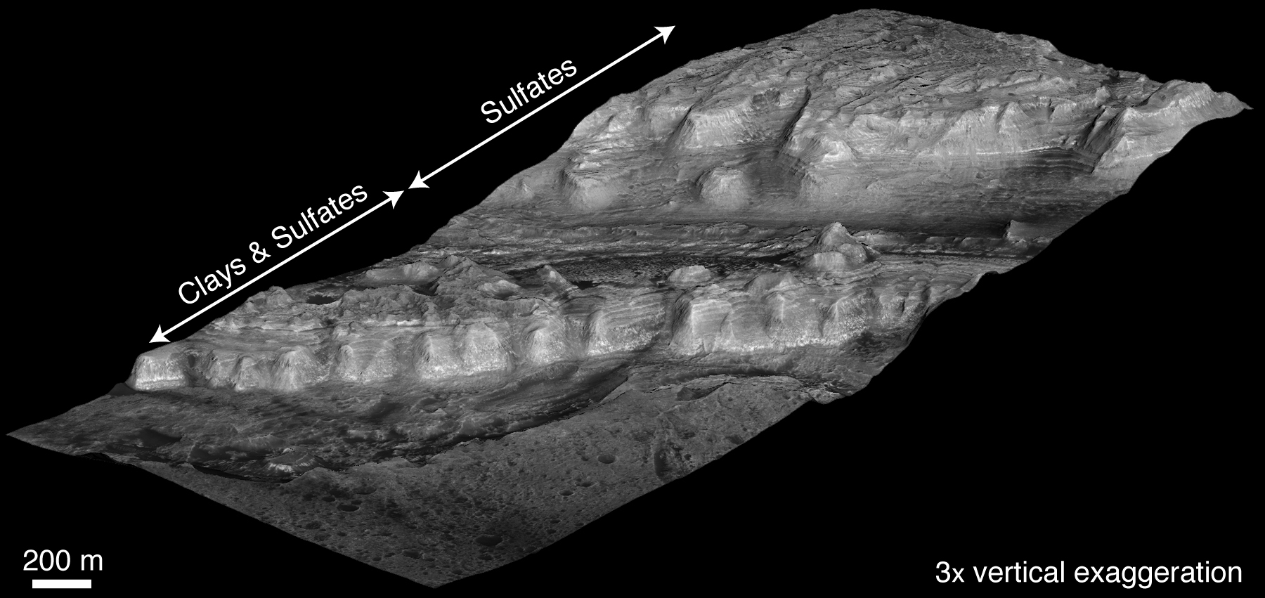
Near the center of a Martian crater about the size of Connecticut, hundreds of exposed rock layers form a mound as tall as the Rockies and reveal a record of major environmental changes on Mars billions of years ago.
The history told by this tall parfait of layers inside Gale Crater matches what has been proposed in recent years as the dominant planet-wide pattern for early Mars, according to a new report by geologists using instruments on NASA’s Mars Reconnaissance Orbiter.
“Looking at the layers from the bottom to the top, from the oldest to the youngest, you see a sequence of changing rocks that resulted from changes in environmental conditions through time,” says Ralph Milliken of NASA’s Jet Propulsion Laboratory, Pasadena, Calif. “This thick sequence of rocks appears to be showing different steps in the drying-out of Mars.”
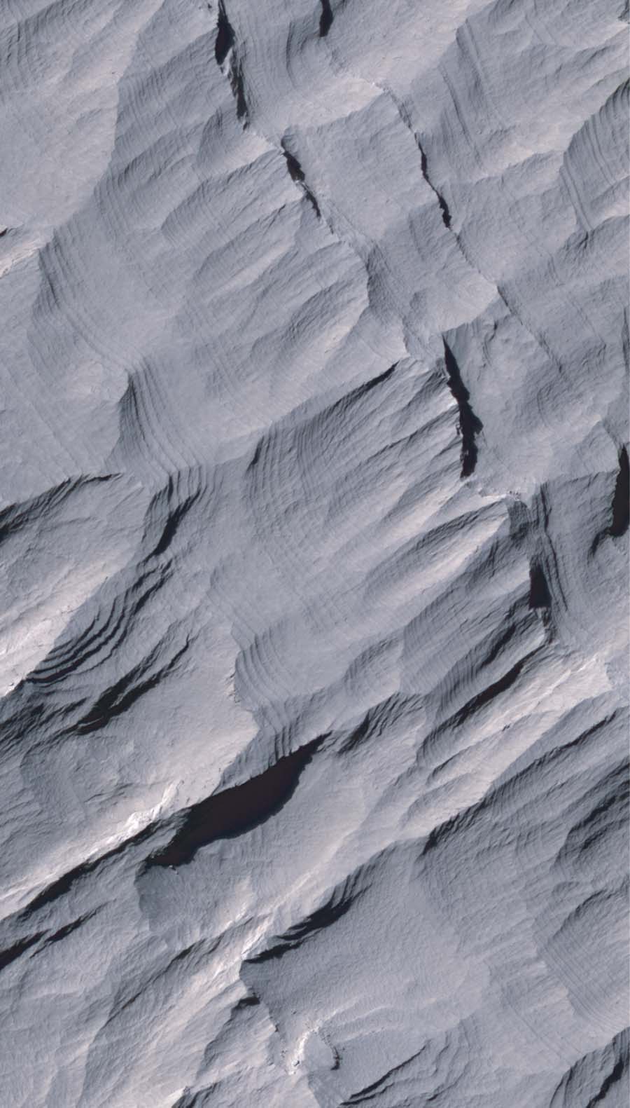
Layers in Upper Formation of Gale Crater Mound
Layers of rock in the upper portion of a tall mound near the center of Gale Crater on Mars exhibit a regular thickness of several meters, unlike the less regular pattern of layers in the lower formation on the same mound. The mound of layered rocks is over 4 kilometers (2.4 miles) high, making it more than twice as thick as the stack of rocks exposed in the Grand Canyon on Earth. Gale Crater is approximately 152 kilometers (94 miles) in diameter.
This view of layering in the mound's upper formation covers an area about 550 meters (1,800 feet) wide. It was taken by the High Resolution Imaging Science Experiment (HiRISE) camera on NASA's Mars Reconnaissance Orbiter on Sept. 8, 2008.
Sulfate and clay minerals that have been observed in the lower formation have not been detected in the upper formation, where bedrock may be covered with dust. Previous studies have suggested that regularly spaced layers such as those in the upper formation might record rhythmic climate cycles linked to changes in the planet's orbit and tilt, or other periodic changes in the environment affecting deposition of sediments.
This image is one product from HiRISE observation PSP_009927_1750, centered at 4.9 degrees south latitude, 137.7 degrees east longitude. Other image products from this observation are available at http://hirise.lpl.arizona.edu/PSP_009927_1750.
The University of Arizona, Tucson, operates the HiRISE camera, which was built by Ball Aerospace & Technologies Corp., Boulder, Colo. NASA's Jet Propulsion Laboratory, a division of the California Institute of Technology, Pasadena, manages the Mars Reconnaissance Orbiter for the NASA Science Mission Directorate, Washington. Lockheed Martin Space Systems, Denver, is the prime contractor for the project and built the spacecraft.
Credit: NASA/JPL-Caltech/University of Arizona
Using geological layers to understand stages in the evolution of a planet’s climate has a precedent on Earth. A change about 1.8 billion years ago in the types of rock layers formed on Earth became a key to understanding a dramatic change in Earth’s ancient atmosphere.
Milliken and two co-authors report in Geophysical Research Letters that clay minerals, which form under very wet conditions, are concentrated in layers near the bottom of the Gale stack. Above that, sulfate minerals are intermixed with the clays. Sulfates form in wet conditions and can be deposited when the water in which they are dissolved evaporates. Higher still are sulfate-containing layers without detectable clays. And at the top is a thick formation of regularly spaced layers bearing no detectable water-related minerals.
Rock exposures with compositions like various layers of the Gale stack have been mapped elsewhere on Mars, and researchers, including Jean-Pierre Bibring of the University of Paris, have proposed a Martian planetary chronology of clay-producing conditions followed by sulfate-producing conditions followed by dry conditions. However, Gale is the first location where a single series of layers has been found to contain these clues in a clearly defined sequence from older rocks to younger rocks.
“If you could stand there, you would see this beautiful formation of Martian sediments laid down in the past, a stratigraphic section that’s more than twice the height of the Grand Canyon, though not as steep,” says Bradley Thomson of The Johns Hopkins University Applied Physics Laboratory (APL), Laurel, Md. He and John Grotzinger of the California Institute of Technology in Pasadena are Milliken’s co-authors.
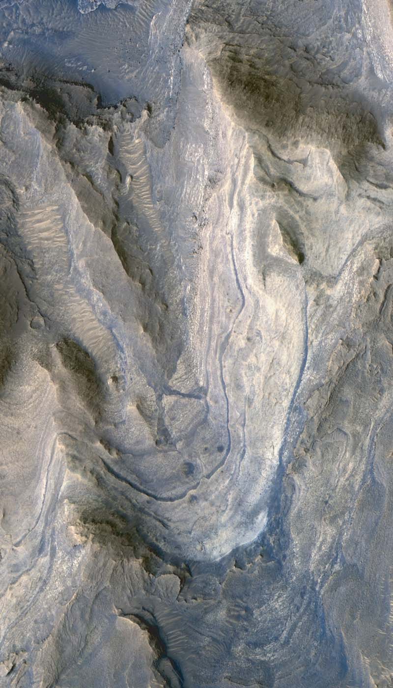
Layers in Lower Formation of Gale Crater Mound
Layers of rock exposed in the lower portion of a tall mound near the center of Gale Crater on Mars exhibit variations in layer thickness and range between dark and light tones. The crater's mound of layered material is over 4 kilometers (2.4 miles) high, making it more than twice as thick as the stack of rocks exposed in the Grand Canyon on Earth. Gale Crater is approximately 152 kilometers (94 miles) in diameter.
This view of layering in the mound's lower formation covers an area about 950 meters (3,100 feet) wide. It was taken by the High Resolution Imaging Science Experiment (HiRISE) camera on NASA's Mars Reconnaissance Orbiter on April 23, 2009.
Observations of the lower formation by the Compact Reconnaissance Imaging Spectrometer for Mars, on the same orbiter, have indicated the presence of sulfate salts and clay minerals in these rock layers. The changes in composition from the lower (older) to the upper (younger) layers in the Gale Crater mound may record stages in water loss and the drying out of Mars.
This image is one product from HiRISE observation ESP_012841_1750, centered at 4.9 degrees south latitude, 137.2 degrees east longitude. Other image products from this observation are available at http://hirise.lpl.arizona.edu/ESP_012841_1750.
The University of Arizona, Tucson, operates the HiRISE camera, which was built by Ball Aerospace & Technologies Corp., Boulder, Colo. NASA's Jet Propulsion Laboratory, a division of the California Institute of Technology, Pasadena, manages the Mars Reconnaissance Orbiter for the NASA Science Mission Directorate, Washington. Lockheed Martin Space Systems, Denver, is the prime contractor for the project and built the spacecraft.
Credit: NASA/JPL-Caltech/University of Arizona
NASA selected Gale Crater in 2008 as one of four finalist sites for the Mars Science Laboratory rover, Curiosity, which has a planned launch in 2011. The finalist sites all have exposures of water-related minerals, and each has attributes that distinguish it from the others. This new report is an example of how observations made for evaluating the landing-site candidates are providing valuable science results even before the rover mission launches.
Three instruments on NASA’s Mars Reconnaissance Orbiter have provided key data about the layered mound in Gale Crater. Images from the High Resolution Imaging Science Experiment camera reveal details used to map hundreds of layers. Using stereo pairs of the images, the U.S. Geological Survey has generated three-dimensional models used to discern elevation differences as small as a meter (about a yard). Observations by the APL-built Compact Reconnaissance Imaging Spectrometer for Mars yielded information about minerals on the surface. The Context Camera provided broader-scale images showing how the layers fit geologically into their surroundings.
“This work demonstrates the synergy of the instruments on the Mars Reconnaissance Orbiter,” says Thomson. “We wouldn’t have as complete a picture if we were missing any of the components.”
The mission has been studying Mars since 2006. It has returned more data from the planet than all other Mars missions combined. More information about this mission is at http://www.nasa.gov/mro.
APL provided and operates the Compact Reconnaissance Imaging Spectrometer (http://crism.jhuapl.edu). The University of Arizona Lunar and Planetary Laboratory, Tucson, operates the High Resolution Imaging Science Experiment, which was built by Ball Aerospace & Technologies Corp., Boulder, Colo. Malin Space Science Systems, San Diego, provided and operates the Context Camera.
JPL, a division of Caltech, manages the Mars Reconnaissance Orbiter for NASA’s Science Mission Directorate, Washington. Lockheed Martin Space Systems, Denver, is the prime contractor for the project and built the spacecraft.